Saturday, August 04, 2012

Cirque of the Towers, July 2012

For photos, see my picasaweb site.


Bob Palais and I went to the Cirque of the Towers July 28-31, 2012. Like many other visitors to this area, our goals were the two 50 classic climbs, Pingora NE face and Wolf's Head E ridge. They would bring my total to 21. Bob had already done Pingora a long time ago, but didn't remember much about the route. We got organized and drove to Farson the day before, staying at Sitzman's Motel. The 9 mile approach to the Cirque from Big Sandy trailhead with camping and climbing gear was pretty taxing for us, but we got set up and were up the next morning at 5:30 ready to approach the NE face. No competitors for this route, I think its length and sustained grade keeps the crowds away (unlike Wolf's Head). Having garnered an excellent topo and route photo from the internet, we were ready for action anxious not to waste precious time on off-route diversions--the possibility of afternoon thunderstorms puts a premium on speed. Today, however, we had no such problems, and once we got fairly high on the route without any sign of incoming weather, we were able to relax a bit.

The first pitch went pretty smoothly on the lead, as I remembered some poster's comments about needing to downclimb a bit for the easiest passage on the traverse. Easy for me as the leader, having gear diagonally above, but it left Bob in an unpleasant position with the next piece far off to the left and only a little up. Better would have been to place a piece at the end of the downward bit, even though it would be below the second climber--at least it would be nearby. Bob managed by climbing an alternate lower line (harder, but better protected for the second). The next 4 pitches were long (160+ feet) and tiring. I've found it recent years that I'm much more comfortable with shorter pitches of 100 feet or so since it limits rope drag and allows for a more even expenditure of energy. I hate that frantic feeling as you get near the end of the rope, extremely tired, with a nearly empty rack, looking for the belay. The climbing suited me, though, with a lot of layback-type moves following a clear corner system. I broke the sixth pitch into two. This brought us to the crux pitch of the route, the wide section, 5.8. There is a 5.9 lieback corner alternative, but this looks rather strenuous. Since this is a short pitch, I led up on one of the 7.8mm ropes, doubled, and trailed the other to haul the packs. This seems advisable since it is hard enough scraping up the thing, why make it even harder dealing with the pack? I did lose a lot of energy on the climbing and hauling, though, and the day's work began to take its toll on me. I had some cramping in my hands towards the end of the next pitch (normally I don't have this problem, but it tends to happen when doing hand hauling--it would have been better to rig something with tiblocs to lessen the toll on the hands). There was some back and forth in postings about whether to bring a #4 Camalot for the wide pitch. As it turns out, the #3 was what I placed at the crux, though I did place the #4 higher up on the pitch. Despite its weight and awkwardness, I think it is good to bring the #4 since the alternative would have been to double up on the #3 size, so the actual weight savings would not be that great. There were plenty of places on the route to use the #4--or perhaps to get rid of it so the second has to carry it the rest of the way up the pitch!

Having completed the crux pitch, we thought we had the route in the bag, but the NE face was not going to let us off quite so easily. Altitude and a long day of strenuous climbing was taking its toll, and our progress slowed considerably. The pitch after the wide bit was a long diagonal corner system with a couple of 5.7 sections. This became something of a psychological crux for me because halfway up I became convinced I was off route as I couldn't recognize some of the features in the topo, in particular the "off route chimney." This remains a bit of a puzzle to me since I now know I was right on route and really, how can one miss seeing a chimney? Some grass in the crack and a lack of a clear destination for the pitch added to my anxiety about being on route. I down climbed a bit to seek alternatives, but Bob reassured me that I was on track, so I forged on to about 160 feet. At this point I was nearly out of gear and rope so I needed to belay, no matter what. I found a small stance but I was a little insecure about the gear placements--I had one good #1 cam and a couple of somewhat flaring placements. I added a #5 rock under the #1 cam and so I was satisfied, but the whole process took quite a lot of time. (From a gear sling with doubles to #2 plus #3, #4, I was left with nothing but 4 rocks on a biner!) As it turned out, given an opportunity to rest and chill out a bit, I recognized that the usual belay was a mere 10 feet to the right, next to a flake which is the start of the last 5.8 pitch. So when Bob came up he shifted over there. The 5.8 pitch was quite interesting, with some delicate moves as one shifts from one crack to the next.

At this point, the topo says there's an "easy chimney" followed by 5.4 to finish the route. The Deep Lake/Cirque guide calls it 5.6. It is too much of an open book to do much in the way of chimney techniques--one has to exploit face holds and jams. I got up about 15 feet, faded, and lowered off. Bob told me he's got this, it's his forte, so I was happy to trade ends. And giving a nod, up the chimney he rose! Not only that, but he pulled up my pack and anchored it above the chimney. Thus unburdened, I was able to drag myself up the thing. We both thought it was harder than the supposed crux 5.8 pitch. The time was 4:30pm (we started pitch 1 at 7:30am).

Despite our tired state, we both thought it would be cool to finish with the optional 5.6 to the NE summit. I was happy just to sit and belay to recover from the "easy chimney." Bob went partway up and I finished the crack, which turned out to be 4 inches wide. Turns out a short rap is needed to get down from the NE summit. We checked out the true summit and rapped down the South Buttress route (our plan had been to TR the K-crack but that wasn't going to happen at this point).

The next day we were recovered enough to get up fairly early and head for Wolf's Head. The approach to the ridge goes up a surprisingly easy feature known as the "grassy ledges." We saw other climbers up on the ridge and hoped that they were far enough ahead to avoid slowing us down. Soon we were on the ridge, and Bob started up the 18 inch wide "sidewalk pitch," and then we simulclimbed to the first tower. At this point we hit the climber traffic, which consisted of a party of 3 and two parties of 2 ahead of us. My first reaction was to just simulclimb through, but the route is just not set up well for passing except at belays, with its assortment of chimneys and airy foot and hand traverses. The leader in the first party of 2 made it clear he would maintain a strict queue, no matter how long it took. I declared it would take us 5 hours to do the ridge, but having concluded there was nothing I could do to speed it up, I lay down on a nice flat, sunny area to wait and nap. Luckily, the party of 3 was anxious not to hold everyone up and asked the next group to play through at the next belay. After declining the offer initially, they did go ahead, and miraculously the logjam began to move after only an hour or so.

The first pitch descended to a bouldery move to bridge over a gap, followed by a chimney that was not a chimney (because you could climb on the outside--that's my kind of chimney!). Then the "piton pitch" which follows a horizontal crack out an otherwise blank wall (here I clipped a crucial pin with just one of our two strands of rope, and Bob arranged a backrope with the other to provide an extra measure of security--we were climbing with the one 7.8mm rope doubled up). We had to wait at the belay after that. Soon sounds of thunder could be heard and dark clouds could be seen in the area. Bob was frantic to get the parties in front of us to move faster, since Wolf's Head, with its sharp ridge and pointy towers, is about the worst possible spot to be in a thunderstorm. Eventually we got going again, and were treated to two beautiful pitches--one with a crack just below a razor ridge, and one with a 3 inch ledge on a 70 degree holdless wall that enabled an easy but very insecure foot traverse (Bob did it as a hand traverse). Between these two pitches we passed the party of 3. From here we could simulclimb to the summit. The six of us reached the summit within a few minutes of each other. It turns out Bob knew two of the other climbers and had even climbed with one of them over 20 years ago in Tuolumne (they were father-son teams, the fathers having climbed the route 34 years earlier). We combined forces for the rather involved descent, which involves six rappels interspersed with sections of scrambling, down, across, and up.

Thursday, March 08, 2012

Spring Break--Joshua Tree March 2012

Annie and I met up in LAX for another Spring Break climbing trip. We’d done two trips to Red Rocks but the last time it was a bit chilly, so we opted for Joshua Tree for warmer conditions. In addition to rock climbing gear, I had brought ski clothes for Annie and Marcia—they would meet in SLC right after our four days in Joshua Tree. See a couple of photos of The Swift at my picasaweb site.

We stayed overnight near the Ontario airport and forged on to the park on March 2. As soon as we stepped out of the car we experienced unexpectedly cold and windy conditions. The winds at J-tree can be brutal, and this was one of those times. Fortunately, we had warmer and calmer conditions for the other days. Today, however, we had to bundle up and seek sun. We were hoping to “warm up” on Right On, a multipitch 5.6 on Saddle Rock, but we could see it was way too cold. I thought it might get sun in the morning but as it turns out, it never gets any sun at all this time of year! The next good option seemed to be Mike’s Books, also 5.6 on Intersection Rock, but that was occupied. So we went around to the other side to do Overhang Bypass, 5.7. Turns out this was a poor choice for a warm-up climb since it has a couple of really testy sections. On the first pitch, one has to work around an overhang capping a trough by moving either right or left. Going right would have meant doing runout 5.7 face on faith alone, since one couldn’t see the face one was traversing onto. Going left looked easier with some pro at the start but also blind higher up and I didn’t have the confidence to plunge into it at this point. So I lowered off a sling over a knob (recovered with a flip of the rope!) and we humbly retreated. Probably just as well as the second pitch features a hand traverse with no feet, hard to protect for the second. Back to Mike’s Book, still busy, so we headed over to do Southeast Corner, 5.6 sport. This is on a dramatic block sticking up into the sky. I knew it would be windy and sure enough we were buffeted. But it was a fun climb. I was thinking of toproping Cryptic 5.8, but didn’t set the rope up well, so we were lucky just to get the rope back, let alone do the toprope. Back to Mike’s Book—the folks there were rapping off as I headed up. This climb features an odd start with a traverse about 10 feet up, a little tricky. I didn’t like the looks of it for Annie following, since a fall there would result in a swing into a wall. I finished the first pitch and thought maybe I could help Annie up with tension going straight up, but it was too steep, actually incut at the base. So I rapped off. At this point I was thinking we’re out of shape, or the J-tree ratings are tough, or both, so we went over to do the Eye on the Cyclops (5.5)—a fun, steep wall leading to a hole in the cliff through which one exits to the other side.

The next day promised warmer conditions, but it was still somewhat chilly in the morning. We headed over to check out Bong 5.5 on the Blob, but that was in the shade and still too chilly. On the way back we found Toe Jam 5.7 on Old Woman, and this was in the sun and went pretty smoothly (although Annie had the usual beginning crack climber reluctance to really use and trust the crack for hands and feet.) We thought now might be as good a time as any to do Right On, since it never would get sun. This is an unusual climb for Joshua tree because of its length--the guidebook lists it as 4-5 pitches, but we did it in 6. Turned out to be something of an adventure. The first pitch is very long and wanders up a slab and is supposed to continue up past a bolt and then a long section of unprotected 5.6. Since there was a nice belay stance before the bolt I broke the pitch there so as not to have to do the runout part and the rest of the pitch with a lot of rope drag. It was all there, but you had to go the right way or it would have been a lot harder. These J-tree 5.6’s really get your attention! The next pitch was short bit climbing alongside a wide crack. Pitch 4 went up a chimney with a tough entrance move. This is rated 5.6+ and it took me three tries to get. I know I’m getting older, but since when did people start adding plus ratings to 5.6? I left the pack at the belay so I could squirm my way up the first 50 feet of the chimney. When the angle eased, I pulled it up, dragged it for a bit, and then finally was able to finish the pitch wearing it. You really had to think about where to go on this pitch so as to keep the climbing moderate. Annie did great with the chimneying (but she pulled on the bolt at the start to get past the 5.6+ entrance move). Two more fun, easier pitches led to the top. All in all, this had to be the hardest 5.6 I’d ever done. On the descent we found the wind and cold had disappeared, so we could shed our warm clothes and experience the park the way it was supposed to be in March. It was getting late in the day, so we headed over to Trashcan Rock to do something short. We did Karpwitz (5.6), which was steep and fingery, it definitely made me think a bit at the crux. I tried to toprope Profundity (10b) but this was ridiculously hard. Maybe I just needed some schooling on J-tree friction, but it seemed way too steep to do as a friction climb, and there were almost no holds.

Day 3: We headed up to do Double Dogleg (5.7), a sweet crack in Rock Garden Valley. I toproped the next climb over, Split Personality (5.9), another great climb (but on the lead it would seem a bit of a project, steep and strenuous, thin crack). Then we moved the car down the road a bit and headed over to do The Swift, a 3 pitch 5.7 which the guidebook said was one of the best in the park. This was a busy day but fortunately the climb was free. A group in the parking lot said they had gotten off route on it the day before and taken 6 hours. So I was a bit paranoid about staying on-route. On the second pitch I stayed with the crack system and it worked out. The third pitch exits right out of the corner to a wild, airy handcrack. Not unlike the place I backed off of on Overhang Bypass, but at least here you could see what you were heading for. At this point we were pretty tired from the climbing and descending in the sun, so we headed over to do some toproping at Echo Cove. Someone had left a rope up on a slab, they said there was a 5.8 and a 5.10 to do, but they seemed ridiculously easy, like 5.7. I had to look these up later in the big guidebook, they were both 5.8 (Sound of One Shoe Tapping, and WAF). I also made a half-hearted attempt to TR Pinky Lee (10d/11a) and then toproped Swing Low (7+/8-)

The last day we went to Hemingway to do White Lightning (7+). This was a terrific line, very long and somewhat strenuous. I broke up the pitch since there was a nice belay about 100 feet up. Annie did great but needed to hang so she could put her belay glove on to protect her hand in the crack. We set up the next climb over for a top-belay toprope—Poodles are People Too (10b). This was a terrific line, I got all but one move. We went to the nearby Dairy Queen Wall to do a group of shorter climbs, all recommended in Gaines’s guide. I led up Scrumdillyishus (7) and Annie got it with one hang. Then, we toproped Frosty Cone (7). After some leaning over the edge of the cliff I found the right spot to toprope Mr. Misty Kiss (8) and Annie got that with one hang. These are fun climbs, steep, but with big scoop-like features (is that why they call it Dairy Queen wall?) and juggy holds. The rap station shown in the guide was not there, as far as we could see. Annie rapped off the TR anchor and I was going to scramble down, but I didn’t like the looks of that so I ended up rapping off a single bolt near the top of Misty Kiss. At this point we were pretty tired, so we thought it would be nice to go back to Bong to finish off the day. This was a fun, short 5.5 handcrack. The only problem is the descent, which I had trouble figuring out from the description in the guide. The folks ahead of us said it was pretty sketchy. Annie rapped the route, and I tried to find the descent but gave up and rapped off a sling I placed on a horn. I could see the descent involved steep, airy downclimbing, although on good holds. Still, it’s kind of strange to gear up for a casual 5.5 crack and then try to downclimb scary 5.3 with lots of exposure. Even with the rap there was a bit of steep downclimbing to get back to the base of the route.

Altogether it was a fun trip—Annie gained some confidence in crack climbing, and I got back into the leadclimbing game after a long absence. My last time on natural rock was a trip to the Gunks with Bob Nov 13, 2010.

Thursday, August 26, 2010

Six routes in the Mont Blanc region--August 2010

This long post contains my trip reports for my month in Chamonix. For photos, see my picasaweb site.

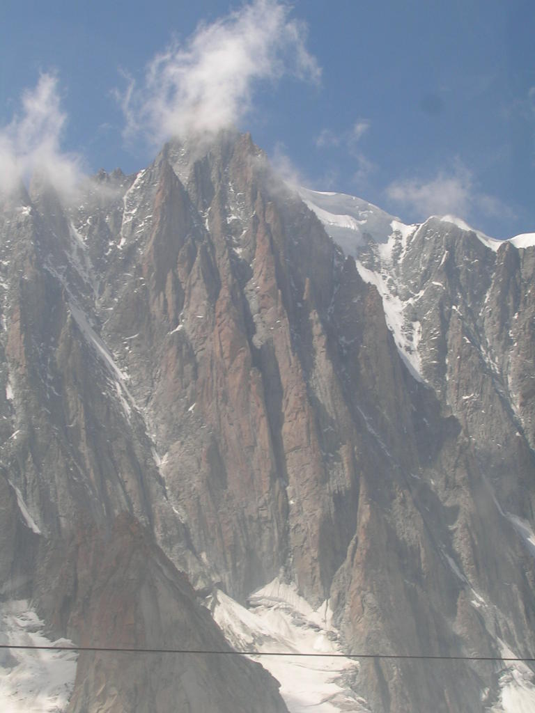
Aug 7, 2010—Brunat-Perroux on Aiguille l’Index

Annie and I were looking for a moderate route with an easy approach as an introduction to climbing in the Chamonix area. The Index seemed like the ideal choice. There is the SE ridge, but that is a little bit too easy. I noticed in the Griffin guide that the S ridge was longer and more sustained, so that seemed like a good goal. However, the problem as always for me was finding the start of the route. There were lots of people going by, we asked them but they kept directing us to the SE ridge. Finally we found a party starting up the E face a couple of hundred feet below the ramp that forms the usual access to the SE ridge. The leader of the group astutely noticed that the route description I was trying to follow was actually on the Gliere, not the Index! I’ve started up the wrong route before, but never the wrong peak. A change of plan was in order. The route they were following seemed about right for us. It is called the Voie Brunat-Perroux, and it contains 7 pitches. The last pitch is 6a, but we avoided that and the rest is maximum 5b, or about 5.8. I noticed that most of the pitches were short, 30m maximum, and this got me to thinking later about climbing with just the one 60m half rope doubled up. This would save a lot of time with pulling in and stacking scads of cord everywhere. For the Index, however, there is a long rappel to get down from the summit so I think two normal ropes are preferred.

The climbing was fun, but not very sustained as the route seemed to hit on various sections of nice rock with interesting moves interspersed with easier terrain. It was completely bolted so for once route finding was not a problem (plus we were following another party). After 2 pitches, we crossed the ramp but then there was a lineup of people waiting for pitch 3 (most of whom had walked up the ramp). Although I was tempted to try to bypass them I decided to wait. At least the parties seemed to move along pretty well and in any event we had plenty of time to complete the route. The upper section contained several hard moves of upper 5.7 or 5.8 that made you think, and Annie did great. More and more people were coming up from below—the good weather turned the route into a traffic jam. The finish was on a short section of the SE ridge and then you needed to downclimb a bit and go behind the peak to access the rappel point. A relatively straightforward descent down a gully brought us back to the Index chair.

At the bottom of the chair I suggested we do the hike over to the Planpraz of the Brevent ski area. This was a very pleasant 2 hour hike and we still had time to do this and ride up for more views at the top of the Brevent tram. (We had bought multiday passes, so the incentive was to ride lots of lifts on days when you were using the pass.) It was interesting to notice changes in the ski area since I had skied it a fair amount in the 60’s. Mainly a lot of new terrain opened up. One thing I remembered vividly was a narrow box canyon that descends from the open slope of the upper Brevent ski area. Seemingly just a bit wider than ski length and steep with rock walls, it was an intimidating plunge for me then and I’m sure it would continue to challenge if I ever get back to ski here.

August 14, 2010—Chapelle de la Gliere

Forecast was OK for the a.m. so Samuel Bieri from the Ecole de Physique and I went to do the S Ridge of the Gliere (or SSE Arete), for real this time. For once I had a decent topo to work off (from the internet). We got the first tram but got passed on the approach. Got a little guidance from a party on a different route for the start, and we started up behind a pair of Brits. The route is fairly long, in terms of number of pitches (12) but many are pretty easy. Also known as the Chapelle de la Gliere, it is one of the routes in Rebuffat’s list of 100 climbs in the Mont Blanc region. Mostly it is max 5a but if you go all the way up the “clock tower” there is a bit of 6a at the top (5.10a). The chapel and clock tower are an unusual feature with a sort of ramp and finger of rock at the top that if you have a vivid imagination, could be the roof of a chapel and a clock tower. We went with one half rope doubled to 30m this time, and it worked out great. Older routes seem to have shorter pitches, so this works great. After a couple of pitches behind the Brits the going was pretty easy so we switched to simulclimbing and quickly passed them by. Fog started to roll in along with a few portentous raindrops. Visibility was so poor it was hard to tell where the ridge went. A couple of times I had to call Samuel off the line he was taking because a glimpse of the ridge revealed he was going the wrong way. We regrouped at the start of the razor pitch (a sharp horizontal arête which is often photographed). This turned out to be easy although I stupidly tried to climb up a corner on the left which I should have known was off-route. We went over the true summit, then did the hard moves on the clock tower. After a short rap we headed off to the col behind the Index and down to the chairlift. The rain picked up later so it was just as well we decided against doing the SE ridge on the index.

August 17, 2010—the Frison-Roche on the Brevent

Again the weather was supposed to be good for the morning, so Samuel and I decided to go up to the Brevent to do a route on the main crag under the cable car. This would be a snap to approach and it finishes right at the station. I finally got some decent guides at Snell Sports. The Griffin guides just didn’t have enough detail. Piola has a couple of topo guides to the region and fortunately there are now English versions. The route we picked was labeled THE classic of the Aiguilles Rouges—Voie Frison-Roche, 6a, 5 pitches. Although we intended to get right up the cable car, we didn’t get to the Brevent gondola early enough and had to wait in line getting tickets. When we got to the bottom of the route there were already 3 parties ahead of us. Fortunately they seemed to be moving along quickly so we waited. Seems like in the US when you get to that situation there’s always somebody who takes 2 hours to do 1 pitch. The classic routes here are crowded but most of the time they move along OK. Pitch 4 was a little hard but didn’t seem 10a, it went up a corner crack. The route was fully bolted so it was a little strange to climb this crack on bolts. Cracks like this are a dime a dozen in Yosemite, but here a nice crack is noteworthy. The Brits in front of us got stuck and they wasted a lot of time switching leaders to have another go. The last pitch was a real nice crack system, definitely worth it.

August 21, 2010—South Face of Aiguille du Midi

A superb weekend forecast, so Christian and I headed up the first cable car to do the South Face of the Aiguille du Midi (Rebuffat route). I had tried this back in 1984 with Joel Feldman, but it was too hard for him and I had gotten the wrong idea on the route by reading the Rebuffat 100 Finest description (which gives a grade of V but that assumes you pull on pins here and there). Done free in a modern style it is 5.10a. But although it is only 200m tall, it packs quite a punch.

Things got going well as we got to the base (Contamine start) first in line. There would be 4 or 5 other parties all trying to get up behind us, so it was quite a traffic jam (see photos at 
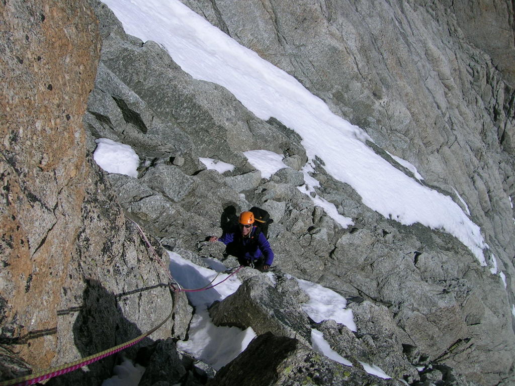
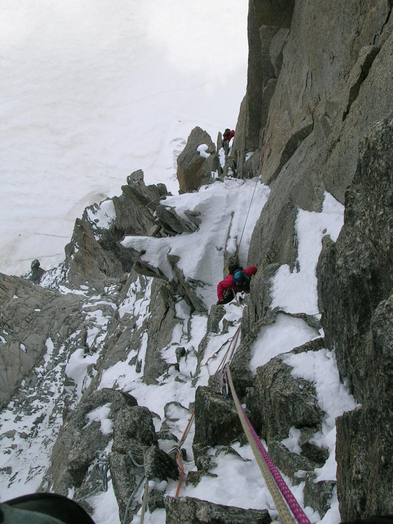
my picasaweb site.). Things went well at first as we cruised the slab move on the first pitch and the S crack afterwards. These are supposed to be the crux pitches at 10a. (Christian was going “old school” by making liberal use of gear to get up.) The next couple of pitches went pretty well also, but there was a little roof that I got pretty winded on with the altitude so I decided to break the pitch there. Since the party behind us were pressuring us a bit, I decided to take a little break and let them go through. Part of my thinking here was that I needed help with finding the route. I could not find a topo and I was just going from a photo with the line marked and the ridiculous 40 year old route description from the Rebuffat book. It’s the sort of description that can be recognized only after completing the route. As you get to the upper part of the face, the number of options seem to multiply and I thought it would be easier to follow a knowledgeable party up the last few pitches. The problem was the party I let through was not all that knowledgeable and the leader immediately ran into problems with route finding. It’s a lot easier to pressure a party from behind than it is to keep up a quick pace in front when you have the additional burden of route finding. The leader clogged up the pitch and another party came up and started passing on the same pitch. The two ropes got stuck together, creating further problems for the leader. At least I had more people to question about where the route goes and how to rappel the route (we had opted to leave our boots, crampons, and axe at the base, figuring to rappel the route to retrieve them). Eventually I headed up myself and we waited endlessly for the leader (Andrea with a German accent) to make the next pitch. Another party joined us at the ledge. I was stacking the rope to get ready for the next lead and the leader of the new party demanded I make room for him. I said I was busy and he just stepped on my rope and forced his way into the anchor. I went ahead and did another half pitch. The pushy guy started to tell me the route moves left. Now I’m getting really confused, whether to follow the obvious crack system which Andrea had taken (but she was having a really hard time higher up, so I was worried it was a dead end) or move left and go up another system. It seemed like the “go left” guy was saying to go way left, but the ledge ended after 30 feet at a major outside corner and there was no obvious way to go further left into the chasm beyond. (The picture on summitpost shows a route going further left here, and since we never saw the go-left party after this point, there must be a way over there. However, it might have been hard for us to rap back down if we had gone that way.) Anyway, I went up the system left of the cracks, which was fine, but this intersected Andrea’s route. Andrea’s party was having trouble with rope drag, so they asked me to remove some of their gear on my way up. The next feature was a hard-to-reach slab with a bolt about 10 feet up. I was not at all sure this was on route, but I figured out a way to get onto the slab and proceeded on. This led to some snowy terrain but I managed to find a belay anchor. Things were really slowing down at a point where I thought we’d be able to cruise the last few pitches at 5.7.

At this point, we could see the top but it was far from obvious how to get there. Luckily another party passed by and gave us some very specific info about how to finish the climb. At this point the better climbers were heading up and right to do a sort of direct variation that finishes right at the summit. This would be the preferable finish, but it was apparently pretty hard, something like 6c or 7a which would put it at least at hard 5.10. The way for average Joe’s to finish was to traverse across a huge inside corner/chasm and then head up a wide crack system to the top. So we’d finally got the needed beta from the “hive mind” of half a dozen parties on the route. All I needed to do now was cruise a couple of 5.7 pitches. Not so fast! The traverse normally involves pulling on a rope as a tension traverse but the rope was snowed in and too far back to be of use. I put in a .75 camalot and made the move—almost out of balance. Christian couldn’t do it without leaving the cam. Andrea and company were supposed to give it back to me, but they needed it too. I became preoccupied with the next pitch and forgot about it. The final pitch began with a strenuous section about 9 inches wide that required me to move the rack to the other side and grovel and squeeze my way up to a stance. Huffing and puffing, and still very perplexed about where to go next, I got further advice from the knowledgeable guy that I needed to go around the corner, drop down a bit and climb the offwidth. He said it was easier than it looks. There was a bolt to lower off of, or protect the traverse, but then it was a full-on offwidth up a very smooth crack (also wet). I struggled with this for a while and got a ways above the bolt—but no other gear was to be had. Just as I was starting to get overcommitted, a couple of holds started to appear and after a scary slip I managed to complete the pitch to a point overlooking one of the Midi station terraces. (This is definitely one of the finishes described in Rebuffat’s book—but there is also another pitch that leads to the true summit.)

OK, so I’m at the top and very close to civilization, but all the delays meant it was getting quite late, about 4pm and we still had to rappel the route and make the last tram at 6pm. So I rapped down the offwidth pitch, figuring Christian wouldn’t be up for it anyway. After I described the pitch to Andrea, she and her partner said they wanted to rap down with us. But then as Christian and I were readying the next rap they arranged to follow an Italian party (they had carried their gear up—seems to me that’s the better strategy as the rappel involved a lot of traversing and was a pain in the butt. Even better would be to leave an extra set of boots and crampons at the Midi station to go down and retrieve everything with.) Down we went. At first we did just 30m rappels because of the need to traverse. Also the terrain was rather broken up so stuck rope was a real concern. In fact even with our single rope we stuck it once. But the nice thing about rappelling single rope is that even if it sticks it is usually not too high up and so not a huge pain to retrieve. Still, I was counting the minutes on the raps, with the better ones taking only 10 minutes. Further down we switched to double rope raps. However, in retrospect this probably slowed us down because of the time spent untangling and feeding the rope down the rappel line. At one point I was trying to make it to a ledge really far over, but then when I decided to give up on it I allowed myself to swing rather wildly back, scraping my ankle. Finally I made it to the ledge where we left our gear (but one of the ropes was stuck in a crack at direct start about 80 feet down and to the left.) Time was running out. Christian rapped down to where the rope was stuck, and I brought him his boots and crampons. We tried to organize for the hike up to the Midi but I forgot his ice axe and had to go back up to get it. Going as fast as we could, given how tired we were, we made it back to the station at about 6:30. Happily they were running the tram a lot later due to the masses of tourists who were at the top needing to get down. Overall, quite an eventful day in the mountains!

August 22, 2010—Voie des Dalles

Samuel spent Saturday at a party for his grandfather’s 100th birthday. Sunday we had planned to do the Frendo Spur, but in view of my lengthy day on the South face of the Midi I suggested we go for a more modest goal, the Voie des Dalles on the Aiguille du Pouce. This is a pure rock route in the Aiguilles Rouges. I had tried this 4 years ago but got off route a few pitches up, ended on a really hard slab climb and rapped off. This was a long route and you have to move quickly if you want to make it back to the Index chair before it closes. Even more so now that the hours of operation were cut back, with the first tram at 8:15 and the last ride back at 4:30. On our way to the tram Samuel mentioned he had his sandals for the approach—this necessitated a return to Les Houches because getting to and from the climb involved a lot of serious mountain terrain. The approach in particular was quite nasty, as you have to hike way up almost to the level of the top of the Pouce before descending some very loose gullies and a “hidden couloir.” This was one of the worst pieces of terrain I’ve ever descended. Then I had to get down some icy snowfields in my approach shoes, using some rocks in my hands to slow my slide. Four years ago, I had taken a more roundabout route that crossed a lower col a couple of peaks to the east. Even if this is a bit slower, it is much preferable.

We took the “Depart des guides” start, which comes in from the right, as recommended by the Piola guide. Things went pretty well until we got to the top of pitch 2 in the topo. This is the critical route finding juncture. The guidebook warned about following a line of bolts left of the route. So I saw the line of bolts, felt good about not following them, and moved right as per the topo. But another tempting bolt lured me in and I did some hard moves up to it and then to another with a left biner. Evidently I was repeating my experience from 4 years ago. But I had enough presence of mind to lower off and figure out that the real route was even further to the right up a seam with grass and a couple of pins. In retrospect, given that this is an old route, I should have followed pins instead of bolts. The problem with route finding is that none of the options seem to lead anywhere from below—you have to proceed up on a little bit of faith. The seam turned out to be really hard, much harder than the 5c rating would suggest. I put in a ton of gear still somewhat in doubt about whether I was on route.

At this point a British party had caught up to us. They said their intention was to flash up the route and make the last chair down. We had already given in to the inevitable, given our late start and the 4:30 deadline. They started to share the pitch with us, which I didn’t mind so much. However, as usual it is a lot easier to move quickly when the party in front is doing the route finding. Once their leader passed me he made some route finding errors of his own and so we ended up doing several pitches in close proximity. I got an interesting comparison between two rope strategies. We were going with our 30m double rope, they were stretching out leads with a 50 or 60 meter rope. They were often out of communication or dealing with rope drag, so we proceeded up much more smoothly and efficiently. This time I was the knowledgeable one, as I had to correct their route choice at one point where the route traverses back left on a jugged out hand-traverse. At the end of this the Brits finally cleared our rope. They had started to simulclimb, using an interesting method of putting a rope block in every so often to keep the second from pulling off the leader in case of a fall.

At this point the angle eased off and we started to simulclimb as well. In the end, we arrived at the top at about the same time as the Brits. We had done a fairly long route in a respectable time of 5 hours. Still, there was no way any of us would make the last chair—in fact it probably had already departed. After lounging around on the summit for a while, we headed back over fairly technical terrain—a knife-edge ridge that involved a fair amount of downclimbing and skirting obstacles. We arrived at the top of the chair at 7 and proceeded down. I was dreading this part of the day but in fact it was only a 2 hour hike down to the car. Strangely, the path to the parking lot was blocked by a golf course and I ended up following a group of French hikers who knew where the gap in the fence was to get from the golf course back to the tram station.

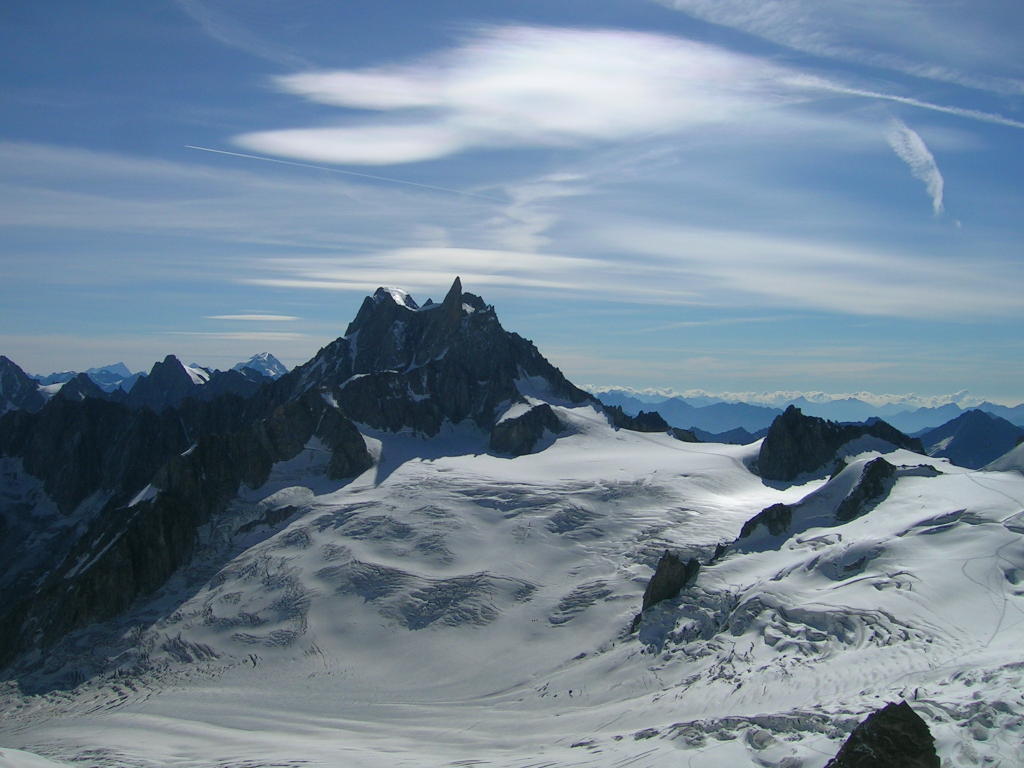
August 25, 2010—Frendo Spur

Bonus day—after taking advantage of the great weekend weather there was another perfect day forecast. So Samuel and I decided to do the Frendo Spur (we were going to do it on the 22nd but I was too tired from the S Face of the Midi). There was a problem, though, with the contracting hours on the Midi Tram. This is a very long route and it is difficult to finish and make the tram back. So we were going to go up the night before and stay at the Refuge de la Plan d’Aiguille (recently upgraded to a full service hut). However, when we arrived to get our tickets, we learned that the tram was closed all day due to winds. After some discussion we decided to get the first tram in the morning and do our best to move quickly.

I was going to do the Frendo with Duncan 4 years ago but I backed out when a third person was invited to join—I didn’t think it would go very well with 3 people. It’s a pretty serious route, on the north face of the Aiguille du Midi. The lower part is rock climbing, and the upper third is ice, so you have to bring everything. This means doing a long route with heavy packs.

We messed up the approach a little bit because I thought I found a nicer way to get to the base by traversing high from the left on the glacier. Turned out to be a pain because the glacier was fairly broken up, we got forced up way high to avoid crevasses, and then we had to downclimb. We lost maybe a half hour and got started at 9. The route starts with easy scrambling and then you need to climb up some steeper terrain to gain the actual ridge. Here we messed up again because when it looked like it was getting harder we didn’t switch to simulcimbing mode with rock shoes. Rather, we just tried to push through the section (supposedly 5.3) in mountain boots. But then Samuel got stuck and I ended up taking a different way up and gave him a toprope. There were some fixed pins with slings to help people get through this section with a minimum of fuss. Once we switched to rock shoes, the climbing went much more smoothly. It was mostly pretty easy, but there were occasional hard parts—such as the blank corner fairly high up that seemed pretty much impossible without pulling on the pins. So much for the 5.5 rock rating! Simulclimbing helped us make a reasonably good time on the rock section, and we arrived at the start of the snow and ice at 1pm.

The ice climbing part started well enough. Samuel was new to it but he had gotten some Simond Anaconda’s like mine. Still, I felt like I needed to lead all the ice. Still in 30m rope mode, we started climbing together and I put in an ice screw every 20-25 meters. A section of about 250 feet got us to the base of the rognan (rock buttress). From here it was necessary to traverse straight out right for about 200 feet. This was a little awkward, but not too bad. The angle seemed like about 45 degrees mostly, in places maybe a bit steeper. (I noticed some tracks later that some parties had gone diagonally up to the right, following more closely the bottom of the ice rather than the top, as I had done—this might have been a bit easier from the point of view of having snowier ice, which took less effort.) At this point my feet were starting to hurt a lot and I was tiring. The ice was generally quite hard (in the sense that it was hard to penetrate with crampon points) so I was on front points the whole way, with only an occasional break in the 10 and 2 position. (An ascent earlier in the season would perhaps provide easier ice climbing conditions, though one might have to contend with more snow on the rock part of the route. I think that the grey-colored ice is generally to be avoided—one looks for routes with white ice that provides easier purchase and less effort.) There were only occasional partial stances at which to regroup and rest. Nothing like waterfall ice climbing where nice stances seem to form naturally. As we continued around the corner and up the right side of the rognan, I could feel my strength waning to dangerously low levels. There were points for cams in the rock every 60 or 70 feet and when I got to a good one I clipped and hung to relieve my screaming feet. At the fifth stance I saw what I thought was an opportunity to move out onto rock and finish up the rognan. This turned out to be a big mistake and a huge time waster. I felt our situation was becoming dangerous since my climbing technique was getting sloppy and we were getting some rockfall from the intense sun on the terrain above us. But one should never substitute wishful thinking for a realistic appraisal of the situation. I climbed up on the rock with my left crampon on and my right one off, and actually did some interesting moves to gain a vantage point. But from there it was clear that the ramp went nowhere and we were just going to have to finish the ice climbing. I was able to clip a half buried fixed cam and lowered/rappelled back to our stance. When I pulled the rope, it got stuck and I had to climb up 25 feet to retrieve it. Finally after an eternity of reorganizing ourselves for ice climbing, I got going. As it turned out the last section of about 200 feet started to ease off and it wasn’t so bad. Perhaps the hour or so I spent off my front points enabled me to regroup and regain some strength and focus. At this point we had given up all hope of making the tram—it was just a question of getting off the face and out of danger. Altogether there was about 1100 feet of ice climbing, which we did in six sections and took about 5 hours, not counting the interlude on the rock buttress. There were perhaps 2500 feet of rock, which took us 4 hours. So obviously being a bit faster on the ice would have been nice, but it’s been many years since I did a long ice climb and I was not in good enough condition for this. The closest thing I had done in recent years was the N Face of Athabasca (2005) which had much softer conditions, and therefore much easier to rest.

At this point we were very close to the top of the ridge. The wind was picking up and it was clear the top of the ridge would be extremely windy. I put on my parka and followed Samuel up to the Midi-Plan ridge. We fought the wind on the short section back to the tram station—our rope blown out sideways like in the old Patagonia climbing movie "Mountain of Storms". At this point it was almost 8pm but there was still some activity in the station leading us to again hope we could get a ride down and avoid a cold night. As it turned out, they held the last tram down (with all the staff and the garbage from a busy day at the Midi station) for a few minutes to help us out. On the way down I chatted with the tram operator who said he had been following us all day. He even had a few comments on the crazy rock excursion! He talked about the orange-coated climber who led all the ice and I confirmed that “I was the orange guy.”

When I took off my boots I found I had lost feeling in the front part of my feet, probably from all the front pointing (though perhaps my boots were too tight for my swollen feet).

Tuesday, August 03, 2010

Charlotte Dome 2010

July 4-6, 2010

Photos at my picasaweb site.

The family was spending a month in Santa Barbara, mid June to mid July (Annie and I were doing some ice-age work at UCSB) so the 4th of July weekend seemed to be a good time to plan for the one California 50 classic I hadn’t done. John was willing despite my warning about the 12-mile approach and the length of the route.

Getting ready involved many hoops. We needed to do a bit of crack climbing as John had never done much of that and hadn’t done much climbing at all in over a year. I heard about some routes in the Sespe Gorge a bit over an hour from Santa Barbara, so we headed over there one afternoon. This is a cliff where Google’s street view serves as an excellent guidebook photo! We did the very long 2-pitch 5.7 route Ending Crack (probably 350’ of climbing) and it was a good opportunity to review crack technique, as well as belaying and rappelling. Our time on this was a not particularly impressive 3 hours. Projected time for Charlotte Dome based on the same rate of ascent is 12 hours (this proved to be accurate). We had some problems managing the double 7.8mm ropes I had just gotten. (The idea was to reduce weight while preserving the retreat options on Charlotte Dome—but it was hard to find a place to put all the rope and it got tangled). We hoped to improve with time with practice. We continued to do a 5.8+ sport route, a quick 2 pitches in fading light (called Free to Choose).

The warm-up climb showed that John needed some looser shoes for the Dome, and we picked them up along with a decent windbreaker. Backcountry permits were reserved (July 3 was already full). I learned we’d need a bear canister. A second rental car was arranged for Marcia since we’d be gone for 72 hours. And so on.

Finally we left at 5 a.m. for the 5-hour drive to the trailhead, stopping for the permit and bear canister in Lone Pine. A little delay from the 4th of July parade in Independence, and the usual trailhead decisions left us with a noon departure on the Kearsarge Pass Trail. Since I did not have my Lowe pack with me, we had to make due with my alpine rucksack and two cragging packs. John took the rucksack with the pads and bags tied to it, and I took the two cragging packs with the gear, rope, and bear canister—one pack on front and one on back. It was slow going up to the pass with the elevation and elevation gain. We reached the pass at 4 and still had 8 miles to go. We got our glimpse of the dome in the distance. The trail eases up for a while but then after Charlotte Lake route finding becomes more difficult as one has to cross the creek a couple of times and follow an indistinct trail of cairns. We lost daylight with about an hour to go but we persisted and were rewarded with a great camp at the spot recommended in the SuperTopo guide. Nobody else here—dare we hope to have the climb to ourselves tomorrow? The guide made it sound like it would be crowded, but really—how many people are going to make the 12 mile trek in?

We got started at 6 the next morning, still slightly worried about other parties who might have been camped elsewhere. Huge mistake not bringing enough water, we had a liter camelback and a partially filled 2-liter bottle. I don’t know what I was thinking. Maybe 3 liters would have done it. The descent to the start went pretty smoothly except we were nervous about the slab crossing and we put on our climbing shoes. Turns out we descended to pretty much this point in our climbing shoes because of all the slabs so a better plan might have been to leave the approach shoes here to save weight on the climb. Made a false start and downclimbed before finding the right one. John cut his hand pretty bad before we even started so we got that bandaged and taped up. Once we got going, though, the first few pitches were pretty easy. I had some trouble getting off route on pitch 5. This was the runout 5.5 section followed by a traverse right to a chimney. Pretty much anything could qualify as runout 5.5 face and then I traversed and there was no chimney to be found. I saw some other trip reports where people got lost here. I think I started from the wrong belay because it turned out I was too low and too far left. There was a note about belaying right after the pink dike, I didn’t see that and put the p4 belay at something that looked like a bolted stance but might have just been a rappel point. In any event, after belaying and bringing up John, I lowered down and swung over so I could see the route better. I found the chimney and got back on route but a lot of time was wasted on what should have been a quick 5.5 pitch. Things got interesting as we moved up to the layback flake and then the crux moves through the slot pitch. This was actually a little hard to figure out but at an overhanging section you just kind of get hands set, lean left and move feet up high on the right—quasi layback style. This was only 100 feet so I led on both strands of one rope and hauled John’s pack on the other rope. This was 5.8 and I wanted to give him a good shot at doing it clean, which he did. We were starting to get low on water at this point, moving slower than I had hoped, so I was starting to get a bit nervous about finishing. John wanted to continue hauling so on the long 5.8 pitch I led on the 7.8mm and hauled on the other. This was a tiring pitch and I used a lot of gear. You can’t really go too light with the rack on this climb unless you plan on really running it out on this pitch. John did great on this pitch as well, so we were pretty close to the top. We still had the furrows pitch, real fun 5.7 but steep. I unwisely decided to continue hauling, but this one traversed and then when I started to haul the line got crossed with the climbing line. John was not experienced with the hauling game and I failed to clue him in on it. With the pack stuck, I also could not pull in the belay rope, so I had to lower myself to free everything. This was kind of sketchy as I was anxious not to waste any more time. Also after I freed the stuff I had trouble bringing the coils of rope up without catching on all the features of the rock in the furrows area. But eventually I got things squared away and we were one pitch away. The last pitch was pretty easy and we were feeling pretty good to finish the climb, even though we had only about 45 minutes of light left.

The descent proved a little tricky to figure out. I knew we were supposed to go out a knife-edge ridge and then down the slabs but as light began to fail it became harder and harder to find terrain that we could safely downclimb. Eventually we just decided to start rapping. We came across a couple of anchors, but the problem turned out to be that once we started rapping, we put ourselves too far right (skier’s right). The slabs are shaped like a circular staircase and the center part is really steep. The easier descent is off to the left, but it took a really long time before we figured out the geometry and then managed to diagonal rappel/walk far enough left to get to easier terrain. We were also moving in slow motion due to the dehydration. It seemed like I spent hours untangling the rappel ropes at each station. After topping out at 8:30 it was after midnight before we managed to get off the ropes.

We still had to find our camp which at this point seemed akin to Stanley finding Livingstone. No trail to follow and only a vague idea of where we were or where it was in relation to us. The problem was not being able to see the lay of the land. Luckily we found a little seep after descending the slabs for a while. We filled up the camelback and our energy returned with the water. The seep was also a clue to our route from the morning since we had crossed it before. We headed over and followed the stream up to the spring near the campsite. It seemed like a miracle but we were back at 3am after a 21-hour day. Turns out John got an introduction to epic adventures as well as to 50 classic climbs.

The walk out just seemed like it would never end and we both started to get serious blisters as we headed down from Kearsarge Pass. Perhaps in the future I’ll try double socks if I get into any hikes this long. I had never been a fast hiker but in our condition the 12 miles out took us 10 hours. Dinner in Lone Pine and the 5-hour drive got back home at 3a.m., 70 hours after we left.

Saturday, March 20, 2010

Red Rocks 2010

March 3-8

Like last year, Annie and I took advantage of the coincidence of our spring breaks to get in some early season rock climbing and tick some of the classics. This year we stayed at La Quinta in Summerlin which was very convenient to the climbing. We found last year the strip was fun for a bit but had limited appeal for us. We did catch another Cirque de Soleil show, though, Ka, which was fun.

Photos at my picasaweb site

Day 1

An early flight and not much sleep the night before landed us at the area around 11am in a rather tired state but we rallied and did
Sacred Undergarment Squeeze Job 5.8*** 1p (bolts)
Brief Encounter 5.8** 1p bolts
at the Panty Wall (shaped like women's panties, I kid you not). Then at the Parking Lot area we did
White Slab 5.8* (but where were the bolts--this was a bit runout--was I on route?)
Man's Best Friend 5.7** 2p bolts

Day 2

Hoping to take advantage of our East Coast internal clocks, and fearful of the crowds on popular routes that gave us fits last year, we got a very early start for Tunnel Vision. However, the weather was not cooperating, high winds and some snowflakes were dogging us on the approach. We bundled up and did the first pitch, 5.7+ but the rock was too cold and we were not having fun so we bailed and headed for sunnier rocks. We returned to the SW facing areas, in particular the Magic Bus which had some nice bolted routes:
Neon Sunset 5.8***
Ken Queazy 5.8 (D)
Technicolor Sunrise 5.8* (A)
Electric Kool Aid 9+* (D tr)
Then we headed up to do
Great Red Book 5.8*** 2p
We misunderestimated how serious this route was, just figured we'd stroll up to it and how long could two pitches of 5.8 take anyway. But the approach was convoluted and then I realized I did not have a second rope which it looked like we would need to rap off. However, I convinced myself we could rap the route next to it with 1 rope and we continued on up (Ka tickets at 7 gave us little margin for error!) The climbing was great, clean liebacking up huge corners. The second pitch (5.8) was pretty testy but Annie did great. The usually very accurate Handren guide did not say how to descend here, so I had assumed it was a rap off. However, when we got to the top it was clear the bolts were just for anchoring, not for rapping. It was not obvious how to descend, and given how convoluted the approach was, with all the zigzagging to get around walls and box canyons, I was not very interested in trying to figure it out. Going with the plan to rap the route next to us (which was actually separated by a huge gap) I got the rope to span the gap and probed down for the anchors, but nothing there! So we just ended up rapping the route, leaving a sling at the top anchors and using a protection bolt in the middle of p2 to get down to the chains at the end of p1. I was able to downclimb from the end of the rope on p1 with a 60 meter rope. Then we really had to hoof it for the car and the MGM Grand!

Day 3

This seemed like a good day to do
Olive Oil 5.7*** 5p
but given our long day yesterday and late night on the town, we did not get a particularly early start. It was not a good sign when I had to park my car up on a bank on the main road because the parking area was full. Sure enough there were about 3 parties at the base and one on the route. I was told to take a ticket! However I did not like this scenario having been burned last year waiting for extremely slow parties on Birdland. The first two pitches were under 200' and looked pretty straightforward, though the second was 5.7. So I soloed up them to quickly get far above the maddening crowds. One guy gave me a hard time, but what the heck. On the last pitch, the party above us for some reason went up a crack in a buttress to the left of the main corner. This route was not in the guide but looked interesting. We stuck with the corner. The crux for us was a testy chimney on the last pitch where I had to clip my pack to my harness and grovel a bit. Very nice route and the gully descent was not bad.

Day 4

Some of the longer *** 5.8's are not particularly sunny, but they are protected from wind, so we decided to try some of them. Today we did
Black Magic 5.8*** 4p
which was indeed a fine route, mostly face climbing, which suited Annie well. The first pitch was a little tricky, but I had trouble figuring out where to belay. The color photos in the guide clearly showed where the route and belay was, but I was looking for a regular stance with two bolts. I climbed higher and back down to the single bolt. Guide says bolt and thread anchor. I guess this means you're supposed to thread a sling through the rock but I didn't realize this until just now. The later pitches look way scarier than they really are. All in all a really fun climb, but it took us a while, maybe 4 hours with the descent which involved a bunch of single rope raps (more than indicated in the guide) and some routefinding to get back to the base. Since we were here we decided to tick a couple of starred routes in the Romper Room area right next door:
Kindergarten Cop 5.7** 1p
Romper Room 5.7*** 1p

Day 5

There was rain in the forecast, and it was cold, so we stuck to short routes.
Ultraman 5.8*** 1p
This was funny as we tried to use a second rope to enable a bottom belay on a 120' route with a 200 foot rope. Next to it was
Clutch Cargo 5.9* (Annie's first 5.9)
both bolted. We went over to do
Ragged Edges 5.8***
but it was getting really cold and some of the crack was wet. Second pitch is wide, also, somewhat reminiscent of Rat Crack on East Peak, CT. Anyway, we figured the first pitch (5.7) would be OK but it was still somewhat intimidating and the crack climbing did not suit Annie very well. She was climbing in the belay gloves--this is not the warm Red Rocks experience we had come to expect from last year! Anyway, I finished by toproping the first half of
Plan F 5.11** to the anchor on Ragged Edges.

Day 6

We had a flight at 4 but figured we'd have time to get in
Dark Shadows 5.8***
Not ideal conditions, with a cold early start and some wetness from the rain the day before. We botched the approach by trying to cross the stream too early. The first two pitches were fine. The third was kind of intimidating. I ran out of pro at about the 100 foot point (despite the fact that the guidebook says single rack of cams!) I think the conditions made me climb conservatively, but it did seem like there were several cruxes and the first one was hard for 5.8. In any event, I lowered and collected enough gear from the first half of the pitch to finish the pitch. I think I might have gone for it if I had saved at least a number 2 camalot for some wider cracks at the top 50'. Annie was not managing this pitch, however, with the cold temps and all the crack climbing. We had overreached. Time to get back home. I was able to tension over to the rap station on the next route over so I could get down with one rope. I toproped that pitch of Chasing Shadows 5.8* and then we were out of there. All in all a great trip, and we managed to do a lot of great climbs despite the unseasonably cold temperatures. Reminder to self to check the weather conditions before making plans!

Monday, August 15, 2005

Gervasutti Pillar-07-23-05

The Gervasutti Pillar on Mont Blanc du Tacul, seen from the Panoramic cablecar.

Here I am on one of the early pitches. There were some people batmanning up some fixed ropes, they descended when they reached the end of the fixed stuff. I'm not sure what their game was. Perhaps the ropes were for people to climb in the pre-dawn darkness.

Saturday I did a very long climb with a fellow I found through a partners wanted book at the Office de Haute Montagne. It was called the Gervasutti Pillar. We stayed at a hut and got going at 3 a.m. (most people get going at 1 a.m.!) Then we had a few routefinding problems, which led to delays, and we weren't speed demons anyway. The top of the route was snowy and icy, which made it a different sort of challenge, that of just getting up in reasonable time. After the end of the pillar per se, there was a sequence of other challenges just to get over to the summit of Mont Blanc de Tacul and the easy descent. Bits of 5th class climbing sprinkled in with lots of scrambling. Anyway, it got dark and we still had one last tower to climb. But wouldn't you know it, my partner (Duncan) dropped or lost his headlamp. So I would lead up a small section, then belay him over while shining the light on it. It was rather eerie, climbing a tower in the dark with no clear picture of where the route went or what the mountain was like away from the beam of my headlamp. On one side it appeared to be a blank face leading down hundreds of feet, beyond the reach of the headlamp, in any case.

At this point we had been going for 20 hours and we were getting really tired. There was a French team which had passed us during the day, but we had more or less kept up with them, partly by choosing better and less time consuming alternatives on the way up. At one point there was another tower to climb, and it looked pretty hard, and since I knew we were going to run out of daylight. The French team weren't sure where to go, but after reading my copy of the route description, I assured them it was the right way. I got Duncan to follow that pitch with a belay from the French leader. (Everyone here climbs with a double 9 mm rope, so it is easy to belay two seconds at the same time.)

Later, we could see the headlamps of the French pair on top of the last tower, but it looked so far away. The wind was coming up and we weren't dressed terribly warmly. Duncan was getting really cold and was really focused on getting off and not having to bivy. Of course he didn't make things easy in that regard by dropping his headlamp! Not that I was terribly enthusiastic about bivying, but I didn't want to do something crazy or unsafe just to get off that night. Duncan thought we could rap down to a gully and climb out of that to the easy ground, thus avoiding the final tower. This proved to be correct, but I was very nervous about rapelling into the dark to terrain only vaguely visible by headlamp from a distance. I rapped down very slowly, with Duncan getting impatient, firstly I had to determine if the ropes reached a safe spot, and then to get an idea of the terrain, whether we could move around safely, how icy it was, etc. I found a stance under an overhang which was somewhat protected from the wind, and at this point I was thinking we'd spend the night, because climbing the gully in the dark didn't seem too great an idea. I started to just get occupied with some task and spreading it out in time (like stacking a rope with lots of tangles) just as a way of passing the time. You don't get so cold as long as you are occupied with something.

By now it was after midnight, so it was just a matter of a few hours until dawn. In fact people start their climbs at 1 a.m., so there was some comfort in the fact that being out on the mountain at that time isn't so bad. Duncan was getting concerned that he might get hypothermia, and eventually I decided the gully didn't look so bad. So I headed up it, and thankfully it was not too bad, and did lead to an easy way to the summit and the easy descent. We got back to the hut at 4 a.m. and just crashed, after more than 24 hours of climbing.

Here's another trip report, from a party that had a similarly epic time.

This photo was taken on a pitch at mid-height on the pillar. The verbal description from the Rebuffat book was helpful because it wasn't always clear where we were on the topo. Also, there are some options, like avoiding A1 cracks with 5.8 climbing, that were worth knowing about.

This photo was taken high on the route, on the icy ramp where the route exits the spine to the right. We did one more pitch on the spine than the French party, because they were having trouble with snow-covered slabby climbing.

The views were superb, here is a shot of the Grandes Jorasses.